by Shari Pomerantz
Are you looking to spend more time hiking this summer, but not sure where to start?
After graduating from college in the Midwest, I rediscovered my love of the mountains and outdoors while working at my first job – Tour Manager at Yosemite National Park – and living in Yosemite Valley. Whether you’re new to California or have lived here all your life, summer is the perfect time to find a new park to explore. In this month’s blog, I talk to my fellow WEN Board Members about their favorite day hikes and backpacking trips, and share our tips for getting outside this season!
Check out the pointers below, followed by a few trail recommendations!
Hiking and Trip-Planning Tips:
Be Flexible
A few of the most popular hikes and campgrounds, including Half Dome and Mt Whitney, can be tough to get last-minute weekend permits for – but many other hikes are just as spectacular, and less crowded. Yosemite releases 60% of wilderness permits 24 weeks in advance and saves 40% for last-minute trips, which are released at 11am on the day before your trip begins. If you haven’t made your summer plans yet, wake up early, get in line, and have a few ideas of hikes you’re interested in. You will get a permit somewhere in the park, and the rangers at the wilderness station will help you pick the right trek for your group. Not a backpacker? Yosemite also has walk-in campgrounds throughout the park. Call campgrounds in advance to see how early you should plan on arriving. Many other parks have similar permitting systems. Check their websites for more information.
Look Outside The National Park System
Getting a reservation in a national park on a holiday weekend is a hassle, but luckily, the National Forests surrounding them can also offer phenomenal outdoor experiences. Consider camping off Highway 108 (Sonora Pass), just north of Yosemite, or in the Tahoe region. You’ll face fewer restrictions on permits, and often even be able to take your dog.
Expect The Unexpected
In nature, you can count on your experiences being affected by weather, fire, rockslides, road closures, etc. If you’re concerned, call a ranger station or campground in advance for an update on local conditions. And don’t hesitate to ask the person you speak with for THEIR favorites hikes, sites, and local eats. Some of my best trips have come from asking “What your favorite less-visited lake or peak for this time of year.” Park employees have chosen their work for a reason, and can be great resources. Don’t forget to store your food properly. It’s never fun to wake up to a wild animal in your tent. (It’s happened to me! So that’s what those “Don’t Feed The Foxes” signs in Patagonia meant…)
Be Prepared
Even if you’re only on a short trip, always carry basic emergency supplies, including food, warm/dry layers, and a first aid kit. Bring a water filter or purification tablets and learn how to use a map and compass (or practice using your new GPS device) before your trip. Cell phones can be great in an emergency – but you can’t count on reception. If you’re unsure of yourself or your skillset, consider taking a class. (At REI, Foster Calm, or another organization) For a complete list of what to bring, consider these checklists: 1, 2, 3, 4.
Take Your Time
Pick the right trip for your group. Are you mostly looking for a workout, or also hoping for time to relax by an alpine lake, spend hours chatting around a campfire, and take some amazing pictures? Don’t pick the most strenuous hike if you’re not sure everyone you’re traveling with has the fitness level to enjoy those steep uphills, especially at altitude. Take it easy, get used to how your gear feels on your back, and look forward to taking a more challenging trip with the same crew later in the season.
Board-Recommended Hikes:
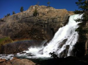 Shari – Grand Canyon of the Tuolumne River, Yosemite National Park
If you love Yosemite Valley but hate the cars, hotels, and crowds, this hike is a great one to check out. You’ll follow the canyon of the Tuolumne River, narrower than Yosemite Valley, for 28 miles from Tuolumne Meadows to White Wolf. Along the way, you’ll pass through a huge variety of terrain, including open meadows, waterfalls, interesting rock formations, and thicker forests – and get to observe changes in wildlife throughout your trip. There are tons of great camping options, including Glen Aulin, Pate Valley, and secluded spots along the river (private waterfalls!) you can have all to yourselves. I visited the canyon as a 3-day girls weekend, but there were so many beautiful places to stop and relax along the river that we all wished we could have spent an extra day. You’ll end your last trip with a steep hike out to White Wolf and car shuttle (or hiker’s bus) before you head home. When you pick up your permit at the ranger’s station, be sure to inquire about water levels and ask a ranger to point out the section of the trail where rattlesnakes sometimes hang out.
Sarah – Sykes Hot Springs, Pfeiffer Big Sur State Park
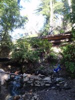 If you’re looking for a long but rewarding overnight backpacking trip just two hours from the Bay Area, Sykes Hot Springs is your spot! Sykes Camp has numerous hot springs located along the river – people have made small sitting pools that trap the flowing hot spring water from the side of the hill. When my group planned the trip in May 2015, we drove down to Pfeiffer Big Sur State Park and camped on a Friday night (if the day you want is booked, you can set a reservation alert for the specific night you’re looking for, and get a notification if/when a spot comes available). Try to avoid holiday weekends or peak summer travel season – weekdays will be even less crowded if you can swing it. Early Saturday, we moved our cars to the trailhead at Big Sur Station. The hike to Sykes Camp is 10 miles (one way!) – I recommend getting an early start so you have some daylight to find the hot springs – doing some online research ahead of time to find descriptions of where they are along the river could be helpful too – we luckily followed a few people until we found a big one (holds 5-6 people), then waited our turn to get in! You can camp at Sykes Camp, or drop your gear at Barlow Flat Camp (7 miles in) and hike out to Sykes and back sans gear (daylight permitting). The trail is hilly and can get hot in the sun, but I definitely recommend checking it out if you’re looking for a difficult and unique adventure. Don’t forget that you should pack out early Sunday because once you are done your 10 mile return hike, someone still has to drive the 2 hours home!
Suzanne – Alta Peak Trail, Sequoia National Park
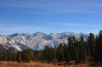 I went to Kings Canyon and Sequoia National Parks for the first time last fall. I stayed in one of the cabins at Grant Grove and did some day hikes. The most memorable – and challenging – hike was the Alta Peak trail. It is a 12.8 mile hike, uphill. The views of the Sierras are spectacular, including the Great Western Divide! There are lots of views of high altitude meadows and forests too. You can also camp along the way (permit needed). While I got a late start and didn’t make it all the way to Alta Peak, I did do about 10 miles of it and really enjoyed it. It’s strenuous, with nearly 4,000 feet elevation gain. The last couple of miles are reportedly very steep and trekking poles are needed. In the fall at least, there were very few hikers, and it was great to be out there hiking on my own with the amazing views to myself! Bring lots of water, as much of the trail is exposed to the sun.
Jordana – California Coastal National Monument, Point Arena-Stornetta Public Lands
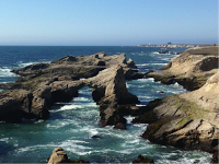 One of my favorite coastal hiking trails and adventures of all time is in the Point Arena-Stornetta Public Lands. Nowhere else can you get such an amazing vista and combination of rugged coastal bluffs, beach, lighthouse, wildlife, and waves crashing through rocky holes. I walked the coastal bluff trail and then traveled down to the rocky beach where I was amazed by the brightly colored sea vegetation and wildlife. Getting to Point Arena is easy, and about a 3hr drive from San Francisco. Once in town, park at City Hall, and then follow the Point Arena Ranch Trail to the water. If you get lost, ask a locale, Point Arena is a very small town with nice people and great food. Enjoy!
Judy – Dog Mountain, Columbia River Gorge
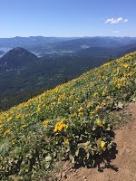 Dog Mountain is a popular hike in the Columbia River Gorge on the Washington side of the river. I’ve done this hike several times in all kinds of weather, but believe me – it’s best when the weather is cooperative: If it’s raining, that rain can turn to sleet and wind by the time you hit the summit. In spring, balsam root covers the hillside, and the views of the Columbia River Gorge are spectacular. Be prepared for a steep 2800 foot assent over 3 ½ miles to the summit and 3 ½ miles back, depending on the trail taken. A great place to stop for food after your hike is SolsticeWood Fire Café & Bar. They recently relocated to Hood River, OR from Bingen, WA, but the 25 minute drive from Dog Mountain is worth the trip to get great pizza and a fine Northwest microbrew or wine.
Christine – John Muir Trail
Last summer, Christine trekked from Mammoth Lakes to Mount Whitney on the John Muir Trail. Check out her blog for more details!
